


Today’s goal was to get to the abandoned town of Picher, Oklahoma. A place of interest in Oklahoma before you get to Kansas. Sitting just on the Kansas border as you drive North of 66.
First, I needed to get through the rest of Tulsa. You drive more through Tulsa on 66 than I did in Oklahoma City. Tulsa, from what I read, funded a rejuvenation project of 66 prior to the centennial. With both the original 1936 route and the realignment route of the 1930s, you had different options to move through the older parts of town.
When you enter the Meadow Gold area, named for the large Mead Golds Dairy advertisement sign, placed atop a large concrete building serving as a Route 66 landmark. This is the Pearl District of Tulsa, a strip of old buildings, a service station turned comic shop, and food places adorned with neon signs. There is some giant things that are also hard to miss. Literal giant statues of characters span down the first few blocks of the street. Meadow Mac the lumberjack, and Cowboy Bob sit just across the street. Buck and Stacy Atom, Sci-Fi comic characters, are the space cowboy/girls that stand outside the service station turned comic book store. Rosie the Riveter stands just down the block, looking over the street as you drive on by on 66.


My other stop on the way to Picher was in Chelsea, OK. You are able to park and walk under Route 66 here. Down some stairs is a tunnel taking you below the historic highway. A mural adorns the left side wall, saying “The Mother Road” in the middle, and postcards painted, taking you east to west on a visual journey of Route 66. The completely white wall to your right inside the tunnel contained signatures and memorials of the people who have passed through the tunnel. Marking them with the names of their families, partners, and companions. Dates and locations of the people who were out to see Route 66 on their own journeys, leaving a signature to let people know they were there. This was like a giant signature book, just a handful of feet below the highway they traveled along.


I make my way through the town of Miami, OK, before I finally pull into Picher. There is not much left at this point. The town was completely abandoned in 2008, a tornado hit the town and finalized what had already been set in motion. For years, lead and Zinc had been mined, water contaminated, and tunnels dug beneath the town, collapsing, causing sinkholes to form. People had been clearing out before the 2008 tornado, but that, from my understanding, is what finally sealed the fate of the town. The government found it easier to simply pay people to relocate and leave the town behind than to provide funding to help rebuild houses that were destroyed by the tornado. [The town would become unincorporated the following year in 2009]
When you get to this town, you’ll notice what looks like sand dunes, large piles of gray, fine dust. What I did find, this is referred to locally as chat. It is what is left over from mining and grinding down lead/zinc. These piles were vast and some were hundreds of feet or more tall. The place did not feel really safe, but I also live next to a reactor that made plutonium during the war along the Columbia River in Washington. So, I pass an old school district building. The Picher Gorillas were state champs in 1984. A now-abandoned fire department, the school building, and the town’s water tower are all that remain along the highway.
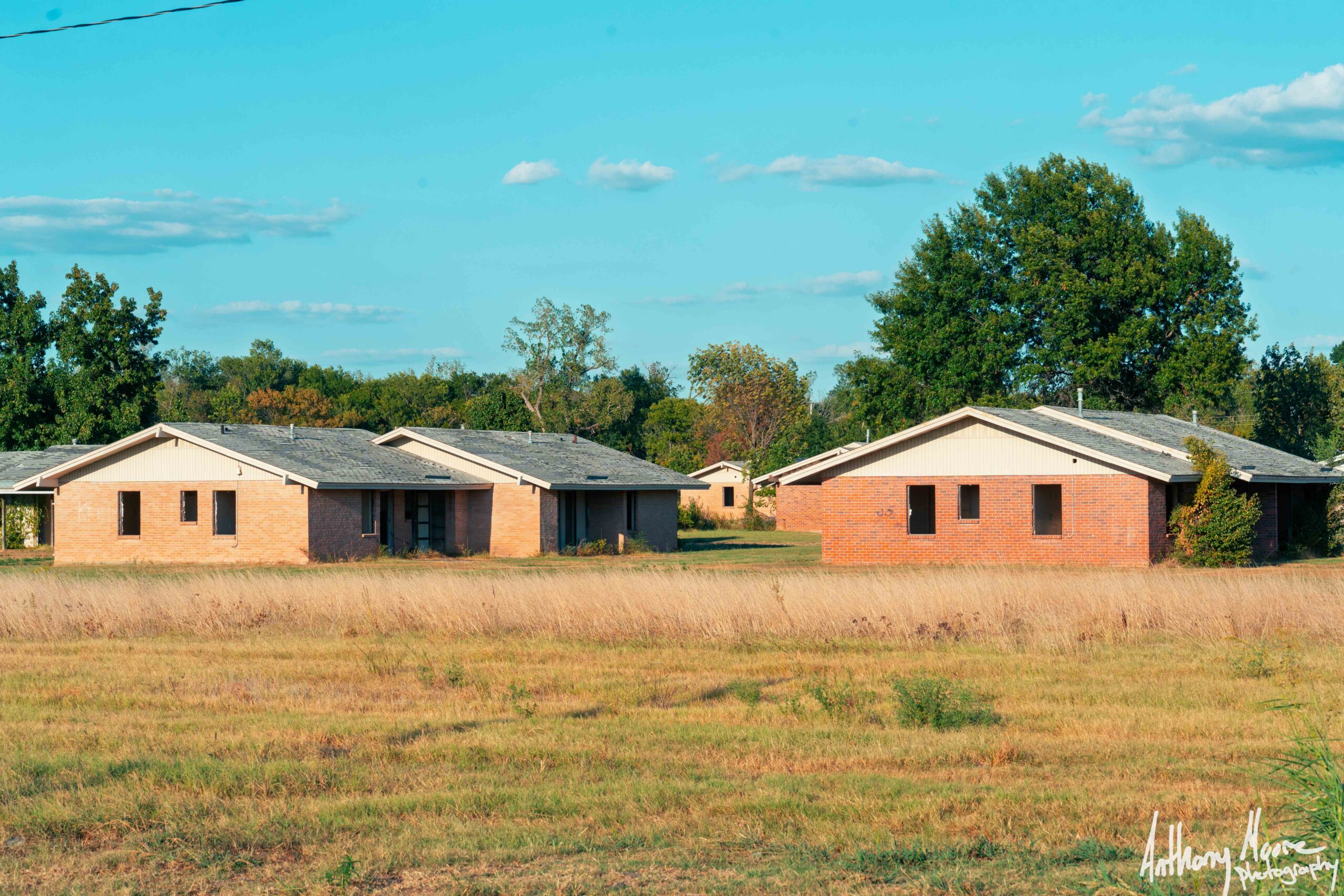
You can see brick buildings to the east from the road. I turn down a road that is just past them and circle back around to the South entry of the neighborhood. There are two houses that appear to be maintained as you come in. There is a Quapaw Marshal truck parked in front of one of those buildings. I assumed it was used for their official business of some sort. The neighborhood loops around, with 20 or so 1950’s rancher-style brick houses still standing. Nature has started to reclaim the buildings, Ivy grows up the brick walls as I would see in the outfield of a Cubs game at Wrigley in the summer.
The buildings no longer have windows. Looking inside from the road, you can see damaged walls from vandals, I’m sure, over the past 18 years. Carved into the bricks, say “KEEP OUT” and the majority of the houses. I’m curious by this place, but I don’t want to approach the buildings since I don’t want to draw any attention, if that marshal at the first house is home. I recorded a video of the drive-through and stopped in the street to take some photos from the car. I would like to know why these houses have been left while the rest of the town was demolished. While this place is interesting its not a tourist spot, it’s probably not safe to be out here for any extended period of time.


I drive around a bit more; most roads and cross sections are closed off. Bricks or fallen trees have been moved in the way of the paved roads to prevent travelers from roaming around the overgrown roads in the trees. I drive by more chat hills, driving by some of the mills. [I’m not sure if these are still actively being used; there are trucks inside the fences of some of the fields I drove by]. I come across the smaller conjoining town of Cardin, where even left is left. Just a water tower and a large two-story wood building that is boarded up are all that remain of Cardin.


The last place I checked out was the high school. The property is fenced off, but the brick building of the school still remains. There are more marshal trucks parked inside the fence, the gate in front of the school is open, but I opt for the side of caution to not enter what is obviously being used by the marshal service. This is also the location, according to satellite maps, where the school’s track and football field were located. I tried to drive around the fence to get a view of the football field, but no luck. The road ended, and I had to back down the pathway to the main road to get out. [There was a baseball field just before this that still had parts of a backstop, the scoreboard, and some concession/bathroom stand that was still standing.]


Just off the highway across from the Picher water tower are two Gorilla statues, a memorial to this town, now lost. Talks of the 1984 championship, what was lost of the town, the government cleanup, and the tornado that eventually ended the town are described on plaques on the site. It was a bit heavy seeing that for decades these mines did only God knows what to the people of this town, with years of lead exposure. The dust particles from the chat piles continue to blow across the land on a windy day.
There was another mural I came across that I also wanted to address. It was for two teenage girls who went missing in 1999. The story goes that the girls were having a sleepover one night when they were kidnapped. The parents of one of the girls were both shot, and the house was burned down with the parents inside. My understanding is that the people who kidnapped and murdered the girls were eventually found. The remains of the girls were never found. The memorials still looked to be maintained, hidden off one of the abandoned roads, tucked away on a plot of land surrounded by trees. [Article about FBI renewed search for remains]


I headed back to Miami for the night to check into my hotel. I drive around the Oklahoma countryside for a bit, looking for some neon signs to photograph. I remembered I got a text from my best friend asking how things were going, so I decided to give her a call. We ended up talking for almost two hours as I drove around aimlessly in the dark of the warm Oklahoma night. We caught up on the trip, I told her about all the random adventures I’ve been on the past 18 days. We caught up on her life and the exciting journey of first-time homeownership she’s on. It felt really good to catch up with her. I miss her a bunch and don’t get to see or talk to her as often anymore since we live cities apart now.


I did finally get to take some photos of the neon Miami had, like the ice cream shop [definitely not infringing on Dairy Queen] called Dairy King, the library’s Route 66 sign, a couple of Miami’s own neon signs. [I randomly came across an old Arby’s cowboy hat sign in the back lot of this sign place. It was random it was the third of the old signs I had seen today. ]Missouri and for a second Kansas is tomorrow for real this time. Where I end up is TBD. I was informed by a sign in Chelsea I am just over 75% of the way across Route 66 now. Soon it’ll be over, then the journey homeward begins.


